The site guide below could be updated at any point in time. You must at all times adhere to our sites guide. There are embedded links in the sites guide to CANP which is the NOTAM (Notice to all airmen) system which we encourage all pilots to do. There are also embedded links to parking, landing and take off options, which link to What3Words and also Google Maps.
If you have any questions about the sites guide, please use the contact form to send us a message.
We all have a duty to ensure that we do nothing to jeopardise our access to the sites.
- Follow the country code
- Park sensibly
- Do not climb over fences – Please use a gate or a stile
- Be courteous to landowners, members of the public and fellow flyers
- Remember to pay any fees applicable on ENTRY to the sites
- Do not disturb livestock or wildlife
- Fly safely and stay within your capabilities
Abernant (Bryn Mawr)
- Wind direction: E (90°)
- Height AMSL: 1050ft/350m
- NOTAM site code: 7.052
- Minimum pilot rating: Club Pilot +50 hours
- Suitability: This site should not be flown by inexperienced pilots or experienced pilots without a site briefing.
Directions:
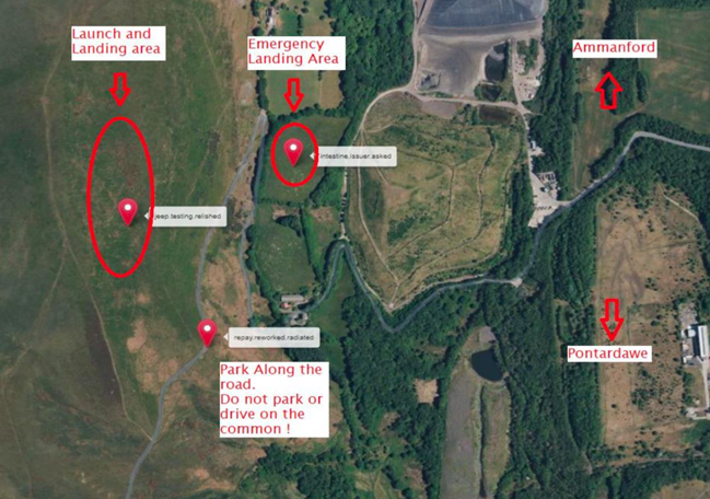
- Parking: ///repay.reworked.radiated
- Parking: Abernant Directions
- Take off: ///jeep.testing.relished
- Emergency Landing: ///intestine.issuer.asked
Turn north at the traffic lights in the centre of Pontardawe taking the A474 towards Brynamman. After about 2km turn left opposite the Travellers Well pub and continue uphill for about 4km. At the crossroads turn right and after a few hundred metres park just before the road heads round the face of the hill.
Landowner site fees:
No fee. The West Glamorgan Commoners have responsibility for this site, we do not have formal permission to fly here. Be polite if you are approached by anybody!
Site rules:
- No flying during the lambing season (March - April) if there are sheep on the hill.
- Do not drive onto the common, and please park without obstructing the road.
Take off and landing:
Take off is shown on the map and using the links above. Top landing is large and undefined just be aware of where you are as there are power lines and fences in the area. There is no official bottom landing If you bomb out there is an emergency landing field (E-LZ on map) There is a rubbish tip, mine spoil-heap and trees to avoid at the bottom. If you do bomb out it means you are not experienced enough to fly here!
Hazards:
Be aware of the power cables and poles running along the face of the hill, they also run close to the parking area. There is no official bottom landing field. Hence the reason that this site should not be flown by inexperienced pilots.
Site comments:
- Good X.C potential.
- Liable to sea breeze.
- Remember to NOTAM/CANP using link above.
Graig Fawr
- Wind direction: WNW to NNW (290° - 330°)
- Height AMSL: 830ft/250m
- NOTAM site code: 7.025
- Minimum pilot rating: Club Pilot +50 hours
- Suitability: This site should not be flown by inexperienced pilots.
Directions:
- Parking: ///marinated.essay.averts
- Parking: Google Directions
- Take off: ///crowbar.gong.beefed
- Landing Field: ///fruits.gates.scrubbing
- HG Emergency Landing: ///bugs.hypnotist.navigate
Directions:
From M4 junction 48 head for Pontardulais. Take the road to Garnswllt, turn right up the hill. Just after crossing the cattle grid take the track off to the right. Within 200m the track splits. Bear left and continue for about 100m. Park in the open area to the right.
Landowner site fees:
The land is owned by The Duke of Beaufort. West Glamorgan Commoners have grazing rights which must not be interfered with. Do not do anything to upset them.
Site rules:
This is an EXTREMELY sensitive site. West Glamorgan Commoners association do not approve of flying activities here. DO NOT: Fly close to livestock. Fly if there are lambs on the hill. Block the track. Drive onto the moor. (From the north or the south).
Take off and landing:
Lots of room to take off, beware of turbulence from obstructions lower down on the hillside. Expansive top landing area. Emergency HG bottom landing field lies in a bow of the river directly in front of take-off ,there is a track down to it over the railway but there is no right of access with a vehicle.
Hazards:
There is no official bottom landing area. The track can be very muddy after spells of wet weather and vehicles have been known to get stuck. Vehicles have been vandalised here.
Site comments:
- Essentially a thermalling site for XC - Not a soaring site.
- This is due to the shallow nature of the slope and turbulence from trees lower down.
- Remember to NOTAM/CANP using link above.
Heol Senni (Fan Bwlch Chwyth)
- Wind direction: NNE to ENE (23° - 70°)
- Height AMSL: 1750ft/533m
- NOTAM site code: 7.004
- Minimum pilot rating: Club Pilot
- Suitability: Club Pilot
Directions:
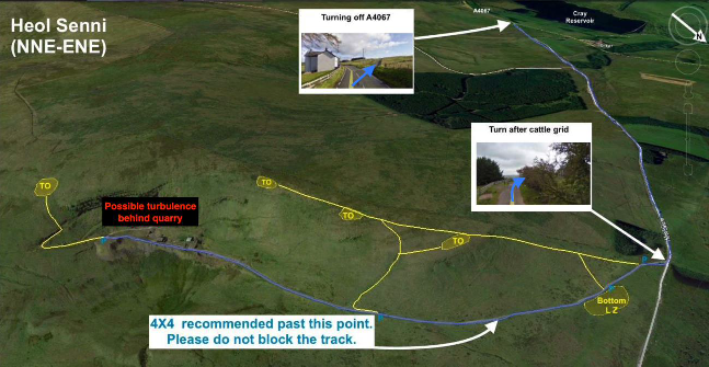
- Parking: ///scans.waggled.tailed
- Parking: Google Directions
- Take off: ///pickup.exit.taxi
- Landing Field: ///beam.baker.bricks
Landowner site fees:
The local council own the land - No Fee.
Site rules:
This is a fairly sensitive site. Share vehicles wherever possible. Do not disturb livestock.
Take off and landing:
There is plenty of room for taking off at either end of the quarry but the slope at the south end is of a gentler gradient and therefore easier to manage in strong conditions. Top landing in front of the wall is quite tricky, but it is okay to land behind the wall if necessary (except behind the quarry where turbulence will be encountered).
Hazards:
If the wind is not directly on the quarry – there will be turbulence – do not fly low over the quarry in strong conditions, beware the dry-stone wall and barbed wire fence behind take-off, many gilders have been damaged here over the years. The bottom landing area below the hill slopes away deceptively. Low flying military aircraft frequent the area during the week – Use the Notam/CANP service!
Site comments:
- An excellent site for thermalling and cross country flying over friendly terrain.
- The ridge itself is fairly short and can get a bit crowded in light soaring conditions.
- Good evening restitution in summer allows flights till sunset. Bare in mind that if you are planning an XC flight from here during the stock resettlement closure of the adjacent Fan Gyhirych site (April & May – check social media for lambing closures) you will not be able to land there.
- If you have to “bomb out” in an emergency on the Cnewr Estate land during this closure period under no circumstances, should you attempt to relaunch, and you will be required to walk out on foot.
- Remember to NOTAM/CANP if flying weekdays (check flying midweek paragraph for instruction guide)
Bryncaws (Mynydd Marchywel)
- Wind direction: E to SE (90° - 135°)
- Height AMSL: 1250ft/418m
- NOTAM site code: 7.059
- Minimum pilot rate: Club Pilot
- Suitability: Club Pilot
Directions:
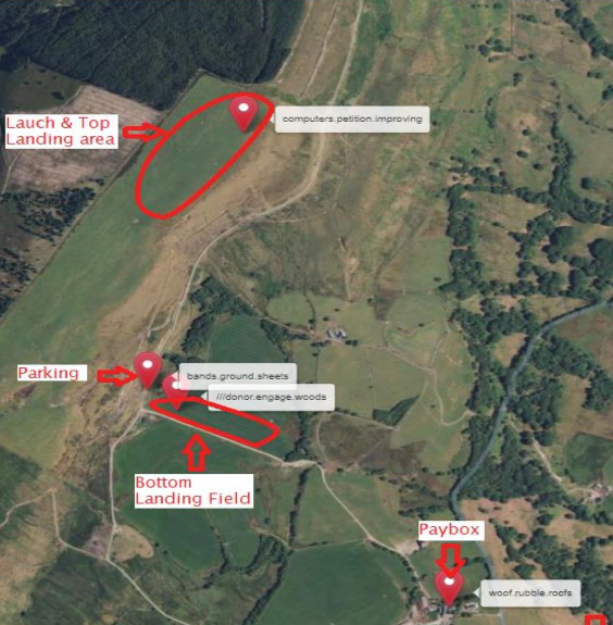
- Parking: ///bands.ground.sheets
- Farm Entrance: Bryncaws Directions
- Paybox: ///woof.rubble.roofs
- Take off: ///computers.petition.improving
- Landing: ///donor.engage.woods
From M4 junction 43, take the A465 northeast towards Merthyr. Turn off left for Cilfrew at the 1st exit and take the next right turn which will take you up through a residential area and into a narrow lane which continues uphill for a further 1km until you reach a left turning that leads to Bryncaws farm. Drive into the farmyard stop and pay site fee then go left around the barn then through the gate between the buildings to the right. The track leads all the way up to the hilltop passing through several gates on the way. Park on the hilltop well back from take-off.
Landowner site fees:
The Stephens family own the farm and the site fee is £2.00 per person including those who accompany a pilot. whether you fly or not and is payable at the farm when you ENTER the site. You can leave your payment in the paybox.
Site rules:
- No flying during the lambing season (Sites officer will notify dates but will be around the March & April period.
- Access is permitted through Bryncaws Farm only.
- Drive carefully and please keep to the track wherever possible.
- Park carefully as to not obstruct the track.
- Leave gates as you find them.
- Do not climb over fences.
- Take care not to disturb livestock.
Take off and landing:
Take-off and top land anywhere along the top. Bottom land in the large fenced-off fields below the hill (see map) the ground slopes away from you.
Hazards:
Can be rough in strong wind conditions especially with an easterly component to the wind Make sure you have plenty of height to miss turbulence from the trees in the landing field. After wet weather, the track can be quite slippery and at times impassable towards the top.
However, if your vehicle is not suitable you may park at the bottom of the hill beside the track. Beware of farm animals in the fields alongside the track or on the farmyard. Young lambs are inclined to run towards passing vehicles and dive under the wheels.
Site comments:
- Approximately 2km ridge with plenty of room to take off and land.
- The north end of the ridge is tree covered but works well.
- The proximity of the site to the coast means that in light conditions during spring and summer, sea breeze can move in sometimes as early as midday and curtail flying (although if you are in the air at the time, it can be the start of an XC flight).
- The site has excellent XC potential. Remember to NOTAM/CANP if flying weekdays.